Challenge Details
The challengers will be provided with high-resolution satellite image datasets (courtesy of DigitalGlobe) and the corresponding training data. We expect them to learn the expected urban elements for each category as detailed below. In the test phase of the competition, the evaluation dataset will be open for them to improve their algorithms. In the evaluation phase of the competition, the test set will be hidden, and the final evaluation will be on this dataset. Live scores, submission and evaluation of the results, and the datasets will be maintained in the website of the workshop (see the Codalab links below).
The challengers will also be required to submit a short paper (up to 3 pages plus 1 page for references) detailing their methodology, which can be extended as a full paper for publication in the workshop proceedings. The submission website is up and running at the CMT link, and please use the CVPR paper template for your submissions. Note that this is not an open call for papers, only solutions that took part in one of the following challenges will be considered for publication.
The challengers will also be required to submit a short paper (up to 3 pages plus 1 page for references) detailing their methodology, which can be extended as a full paper for publication in the workshop proceedings. The submission website is up and running at the CMT link, and please use the CVPR paper template for your submissions. Note that this is not an open call for papers, only solutions that took part in one of the following challenges will be considered for publication.
Challenge Tracks
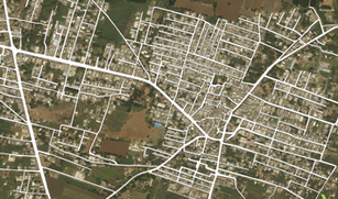
Road ExtractionIn disaster zones, especially in developing countries, maps and accessibility information are crucial for crisis response. We would like to pose the challenge of automatically extracting roads and street networks from satellite images. This will be a binary segmentation problem to detect all the road pixels in each area. The evaluation will be based on the accuracy of the road pixels.
|

Building DetectionModeling population dynamics is of great importance for disaster response and recovery, and detection of buildings and urban areas are key to achieve so. We would like to pose the challenge of automatically detecting buildings from satellite images. This problem is formulated as a binary segmentation problem to localize all building polygons in each area. The evaluation will be based on the overlap of detected polygons with the ground truth.
|
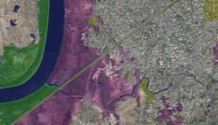
Land Cover ClassificationAutomatic categorization and segmentation of land cover is of great importance for sustainable development, autonomous agriculture, and urban planning. We would like to introduce the challenge of automatic classification of land cover types. This problem is defined as a multi-class segmentation task to detect areas of urban, agriculture, rangeland, forest, water, barren, and unknown. The evaluation will be based on the accuracy of the class labels.
|
Winners
PrizesFirst three places in each category will receive cash and/or equipment prizes!

|

PresentationThe winner in each category will be invited to the workshop to give an oral presentation. The best five submissions of each track will be invited for a poster presentation.
|
PublicationSelected papers will be published in IEEE CVPRW proceedings, visible in IEEE Xplore and CVF Website.

|

DinnerAll participants will be invited to our workshop dinner to meet and talk with the organizers and presenters.
|
Important Dates
March 8, 2018 Call for challenge and introducing the training data
March 15, 2018 Opening submission site (development phase)
March 15, 2018 Opening paper submissions
May 1, 2018 Paper submission deadline
May 1, 2018 Opening second round (evaluation phase)
May 15, 2018 Challenge submission deadline
May 20, 2018 Paper notification to authors
May 25, 2018 Camera ready deadline
June 1, 2018 Challenge notification to authors
June 18, 2018 DeepGlobe Workshop at CVPR2018